
GIS & Mapping
Digitize Your Infrastructure Assets
Building, Developing and Optimizing your Data Warehouse
Do you have paper maps and need to have a simple GIS system built? Or do you have a GIS system that needs to be updated and revised? We can help.
GPS (Global Positioning System) capture plays a crucial role in the asset management of wastewater infrastructure and facilitates the creation of a comprehensive asset inventory by accurately mapping the locations of pipelines, manholes, treatment plants, and other infrastructure components.
Accurate GPS data contributes to better planning for the replacement or upgrade of assets. Knowing the precise location and condition of assets aids in budgeting and allocating resources effectively over the asset lifecycle.
View and download more information about this service:
Duke's Services
Have A Question?
Contact Us Today!
GIS & Mapping
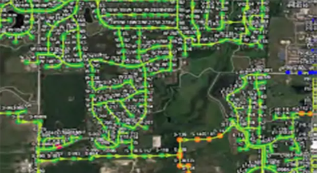
Duke’s collects the horizontal and vertical GPS coordinates for all manholes and pump station wet wells to populate your GIS Database. All depths collected with a grade pole are relative to the center of the manhole rim. Our team utilizes the latest equipment and methods to provide accurate rim elevations to calculate invert elevations and grades for modeling. A robotic total station is utilized if GPS is not feasible in a specific situation or location.
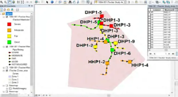
GIS Database Development
To ensure proper snapping and connectivity of the features inside your geodatabase, sewer features are built inside the database and run through geometric network and topology checks. Data is imported into software to identify any problems and refine the QA/QC procedures using these parameters:
- Sewer mains are drawn from manhole to manhole in the direction of flow.
- Sewer force mains are drawn from feature to feature (i.e. ARV to manhole) in the direction of forced flow.
- Manholes, pump stations, and ARV’s are snapped to the endpoints of lines.
- Data collected on pipes in the attribute collection are transferred to the sewer main feature in the GIS, including the upstream and downstream elevations of the pipe.
- Traces are performed to verify the physical connectivity of the points and lines and to ensure pipe material and diameter changes occur as expected.
- The pipe slopes are calculated and analyzed. Outliers of negative, flat, or very steep slopes will be checked.